Simplified Subway Maps
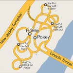
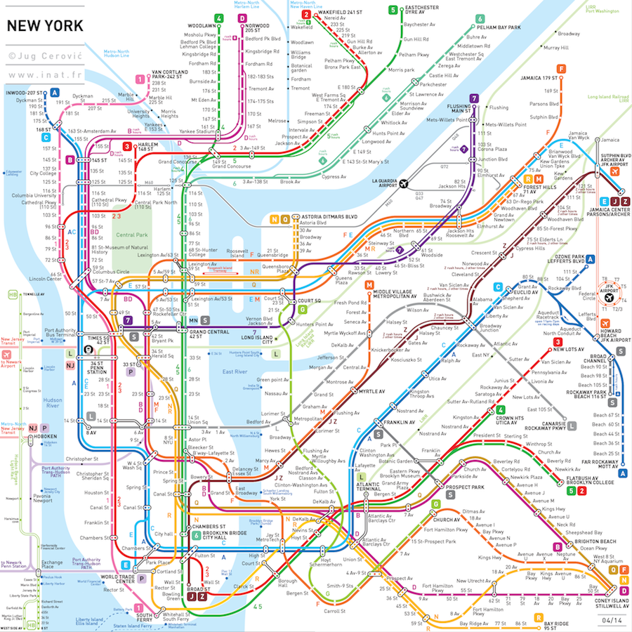
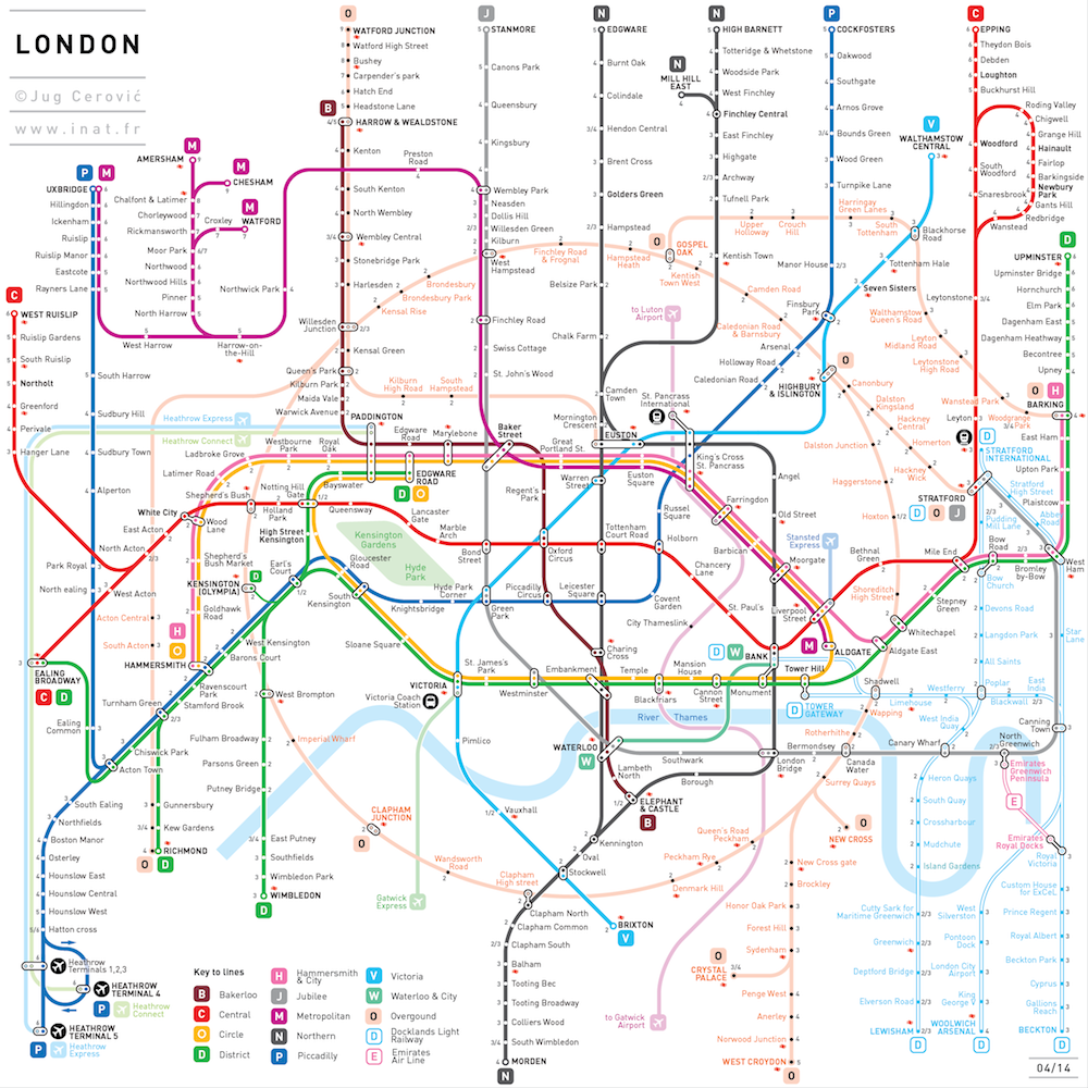
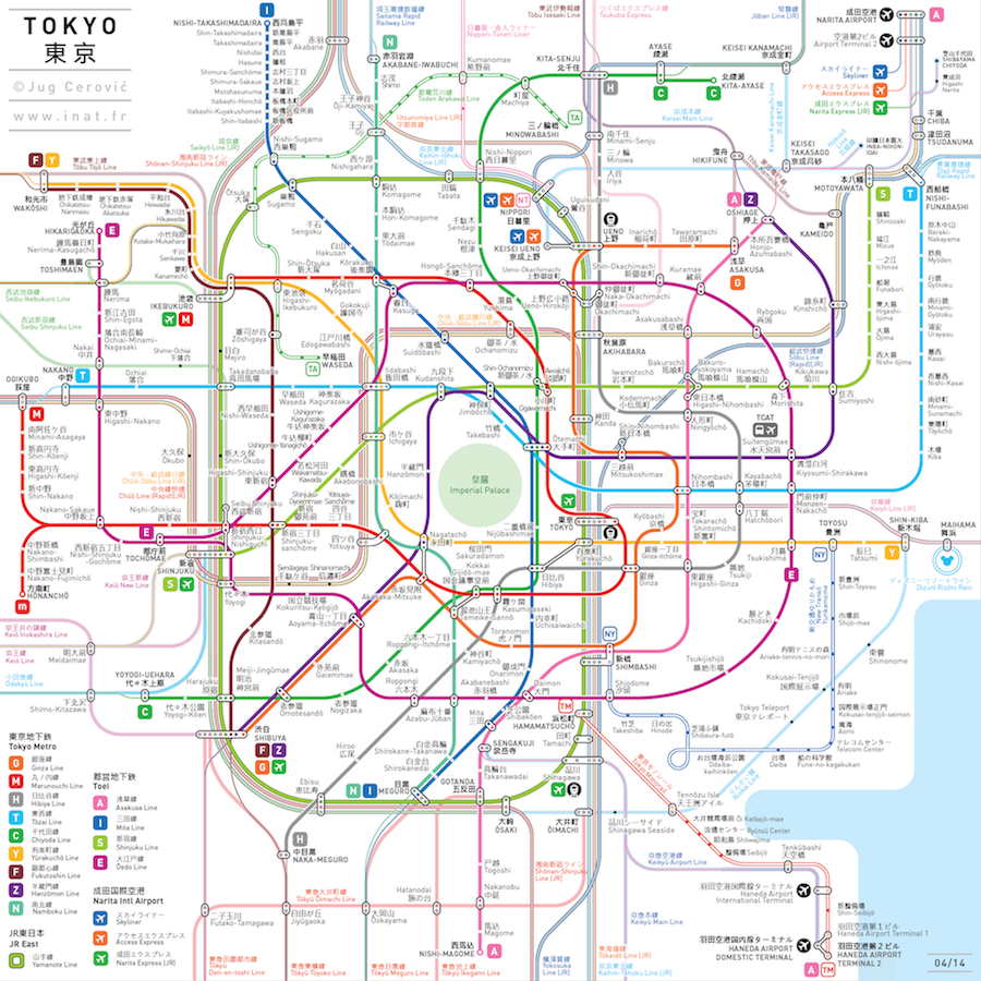
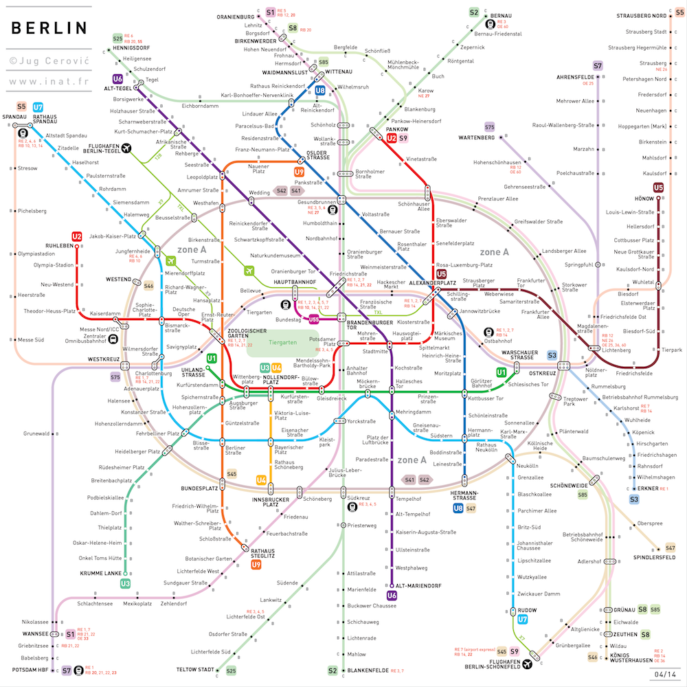
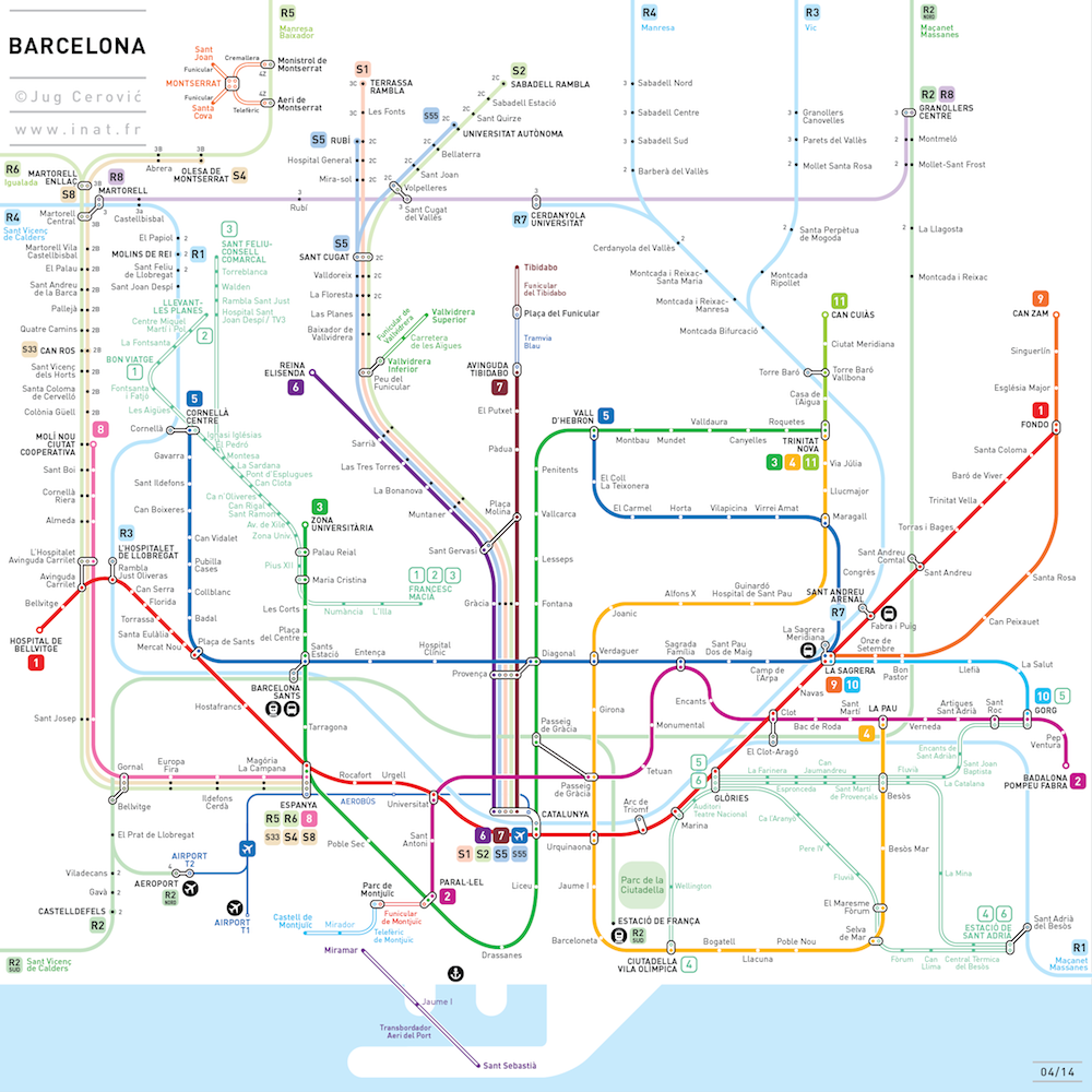
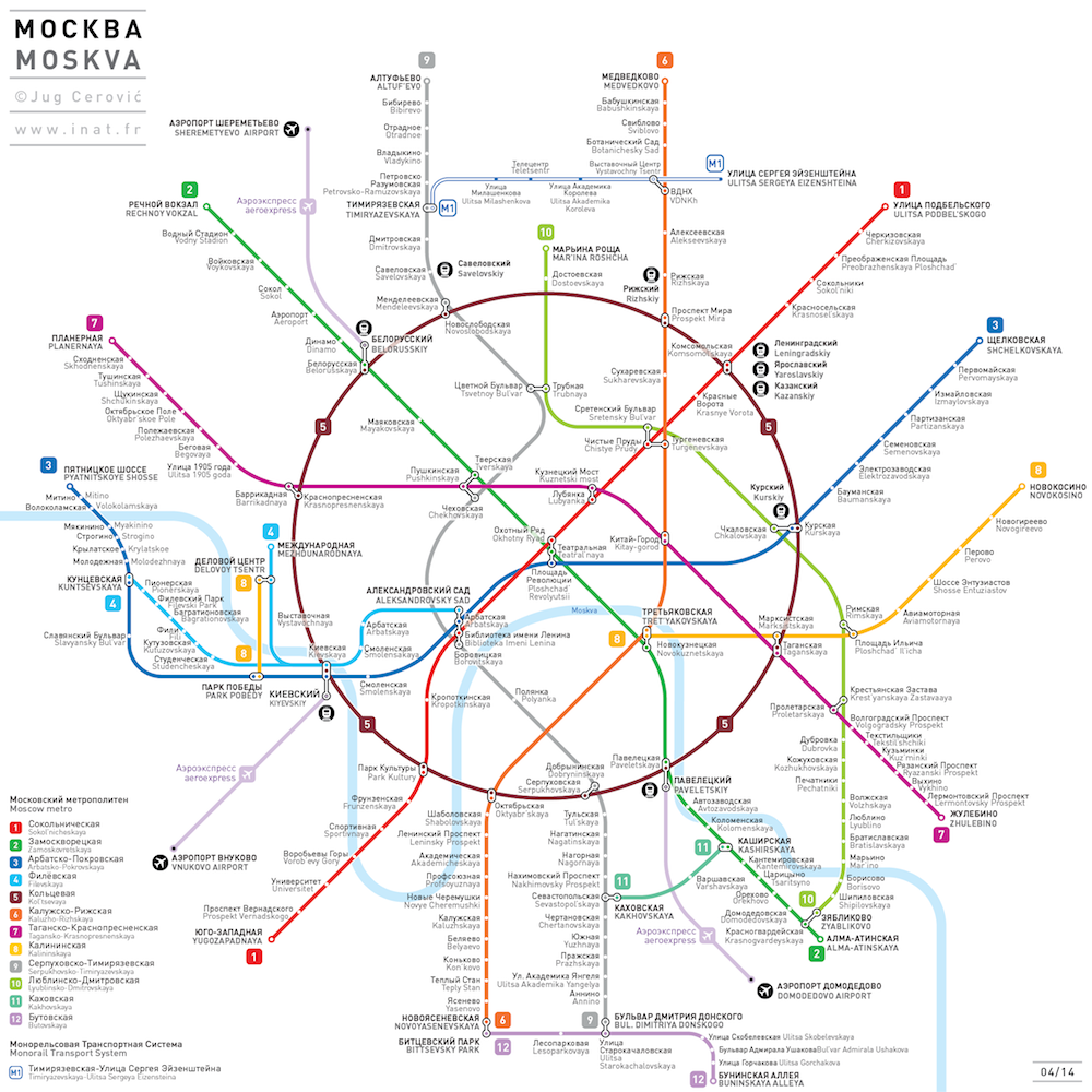
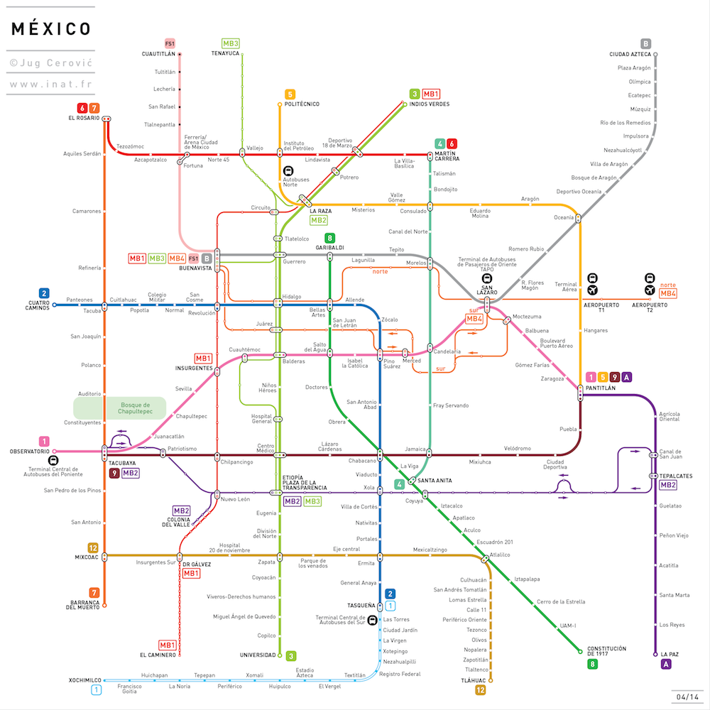
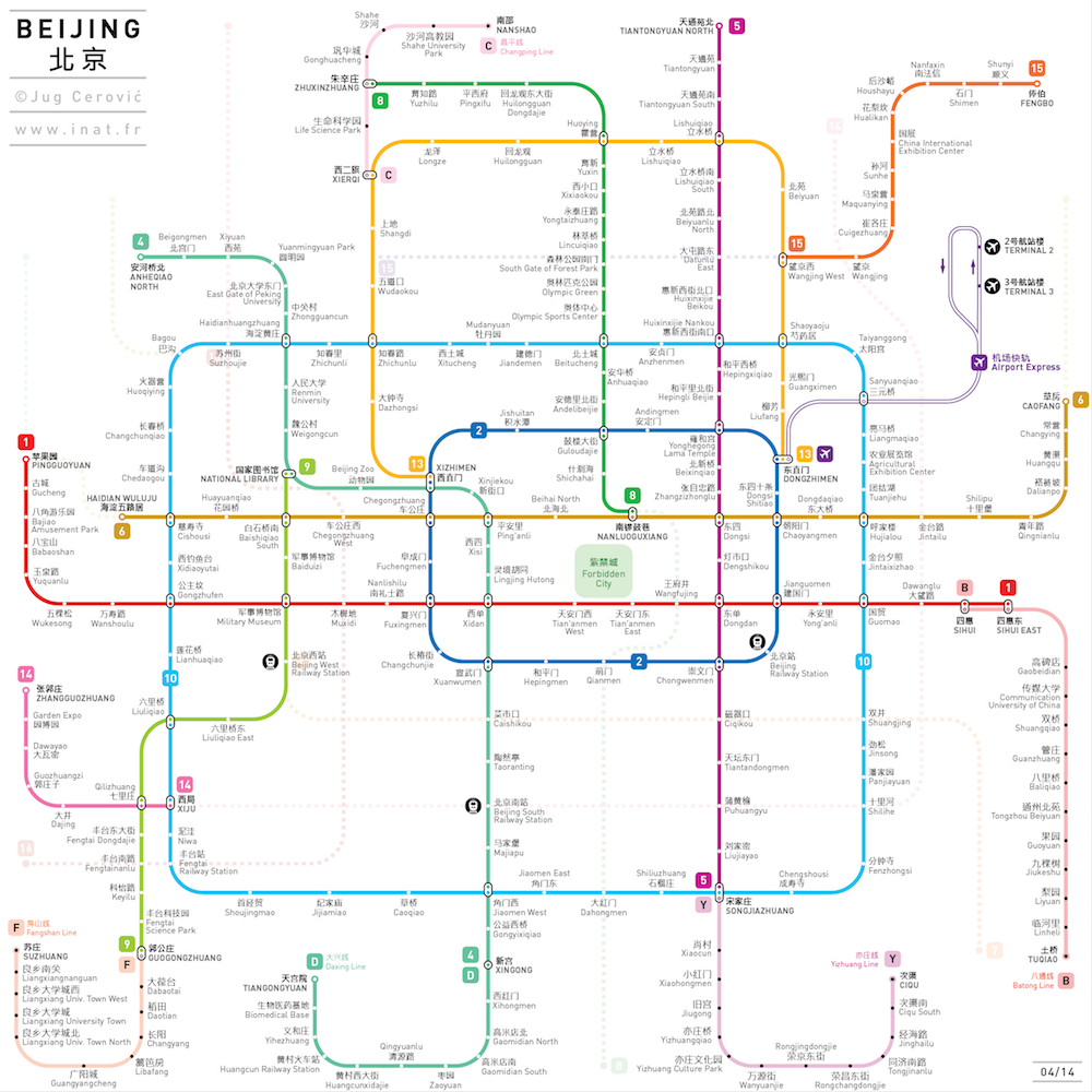
L’architecte Jug Cerovic s’est amusé avec les stations de métro du monde entier. De New York, à Paris en passant par Tokyo, il a remis en ordre le métro en démêlant les lignes entre elles et en simplifiant les trajets qui respectent désormais la réelle architecture des villes. De nouveaux plans de métro à découvrir ci-dessous.

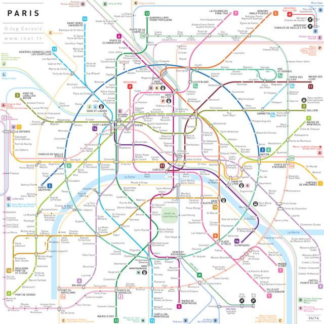
Voir Paris en plus grand.

Voir New York City en plus grand.

Voir Londres en plus grand.

Voir Tokyo en plus grand.

Voir Berlin en plus grand.

Voir Madrid en plus grand.

Voir Barcelona en plus grand.

Voir Moscou en plus grand.

Voir Mexico en plus grand.

Voir Beijing en plus grand.

10-subway-maps-beijing
9-subway-maps-mexico
8-subway-maps-moscow
7-subway-maps-Barcelona
6-subway-maps-madrid
5-subway-maps-berlin
4-subway-maps-tokyo
3-subway-maps-london
2-subway-maps-nyc
1-subway-maps-paris

Uma incrível nova funcionalidade do Google Maps que vai ser mania nesse 1º de abril

Todo primeiro de abril é sempre assim, mas a cada ano parece que as empresas de tecnologia se esmeram ainda mais na brincadeira. Hoje, o que promete acabar com a produtividade do seu dia é o Desafio Pokémon do Google Maps. Basta atualizar o app no iOS ou Android, tocar no campo de pesquisa e selecionar a opção “Press Start” para começar o jogo, que mostrará diversos pokémons na tela do mapa do Google.

poke

Para captura-los basta clicar sobre um dos bichanos e selecionar ‘catch’. Uma divertida brincadeira que promete ser uma mania desse 1º de abril. Vale lembrar que a suposta vaga de Pokémon Master no Google é, obviamente, uma piadinha de dia da mentira. O que não impede você de se divertir com o resultado dessa bela parceria entre Google e Nintendo.

pokemon-master2
pokemon-master

[O título deste post está em conformidade com a nossa nova política editorial. Saiba mais.]

Airline route maps haircut / Ras la frange?

airroutes2008 airroutes20109BBDOgermany
THE ORIGINAL? 
Ana Aeroportos Lisboa « Lisbon airport has a new look » – 2008
Source : EPICA Awards GOLD
Agency : BBDO Lisbon (Portugal)
LESS ORIGINAL
Braun Satin Hair Brush – 2010
Source : Coloribus
Agency : BBDO (Germany)

Food Maps

L’artiste néozélandais Henry Hargreaves a travaillé avec la styliste Caitlin Levin et le graphiste Sarit Melmed pour la série « Food Maps ». Le projet consistait à former des cartographies de différents pays en utilisant des aliments correspondant aux représentations gastronomiques de chaque pays.


CountryFood-11
CountryFood-10
CountryFood-9
CountryFood-8
CountryFood-7
CountryFood-6
CountryFood-5
CountryFood-4
CountryFood-3
CountryFood-2
CountryFood-1
0

Another Handy Map of the U.S. Shows Each State’s Biggest Liquor or Beer Brand

The only downside to Steve Lovelace's Corporate States of America map, showing the most famous brands founded in each of the 50 states, was that there wasn't enough liquor involved. Only two were alcohol brands: Coors and Anheuser-Busch. Thrillist has decided to rectify that with its Red, White & Booze map, "plotting the biggest/most high-profile liquor or beer companies" in each of the 50 states. Check out it out above, and see a much larger PDF on the Thrillist site. Let the debates begin. First of all, why not Magic Hat in Vermont?

Not pictured and/or hard to read:

Alaska: Alaskan Brewing
Hawaii: Kona
Vermont: Hill Farmstead
New Hampshire: Smuttynose
Connecticut: Willimantic
Rhode Island: Narragansett
New Jersey: Jagermeister
Delaware: Dogfish Head
Maryland: Flying Dog


Continental Drift / Le dessous des cartes

animalearth2012 animalearth2012b
THE ORIGINAL? 
WWF « We are one » – 2012
Source : Cannes SHORTLIST
Agency : BBDO Moscow (Russia)
THE ORIGINAL?
Wildlife Preservation Organization – 2012
Source : AdWeek
Agency : DDB & Co Istanbul (Turkey)

Explore o seu mundo com Google Maps

Um cubo labiríntico gigante demonstra algumas das funcionalidades do Google Maps no mundo real. Essa é a ideia da Venables Bell & Partners, de San Francisco, na primeira campanha criada pela agência para o Google, chamada “Start Here”.

De maneira analógica, o labirinto mostra que com o Google Maps você pode acessar o mapa de interiores, como shoppings, ver sugestões de rotas alternativas em caso de congestionamento, e até guia de transporte público.

Além do vídeo, a campanha inclui o site: maps.google.com/starthere

Brainstorm9Post originalmente publicado no Brainstorm #9
Twitter | Facebook | Contato | Anuncie


Advertisement


Interactive Projection Mapping

Après Interactive Multitouch Sphere, voici cette projection interactive axée sur le mapping pour le client Nokia et son produit “Ovi Maps”. Une installation produite à Covent Garden dans Londres par le collectif Seeper. A découvrir en vidéo dans la suite de l’article.


ovi2

Previously on Fubiz

Google Maps Manipulation

Une série de visuels détournant l’outil Google Maps par l’artiste Christophe Niemann qui travaille notamment pour The New York Times. Il montre avec brio son talent pour tourner de façon judicieuse et amusante la charte graphique. Plus de visuels dans la suite de l’article.


christoph-niemann-1

christoph-niemann-3

christoph-niemann-4

christoph-niemann-7

christoph-niemann-8

christoph-niemann-9

christoph-niemann-11

christoph-niemann-13

christoph-niemann-14

christoph-niemann-15

christoph-niemann-16

christoph-niemann-20

christoph-niemann-21

christoph-niemann

christoph-niemann-10


Previously on Fubiz

Nokia | The World’s Biggest Signpost

Nokia Maps

Se você perdeu, não deixe de ver o vídeo-case da Farfar sobre “a maior placa de indicação do mundo”. Apesar do velho uso do superlativo para chamar atenção, a ação criada para a Nokia conta com interação das próprias pessoas, que indicam lugares no serviço de mapas da marca.

A estrutura de 60 toneladas é capaz de se mover para a direção correta, e indicar a distância exata do lugar. O trabalho fez parte da tentativa atual da Nokia de se tornar referência em navegação, e aconteceu um pouco antes de tornarem o Ovi Maps gratuito.

Brainstorm #9Post originalmente publicado no Brainstorm #9
Twitter | Contato | Anuncie

Google Maps Street View Sees All

Less than two years ago, people began to see cars equipped with strange video equipment driving all over the U.S. Google apparently commissioned a fleet of cars for their street view project, which is now live. I decided to give it “test drive” to see what the hype was all about. It turns out that street view gives you just that. A view of the streets from a drivers perspective. I tested it on my street and found it cool, yet creepy. I’m not suggesting in any way that Google has voyeuristic tendencies, but they can get pretty detailed. I was able to see my roommate’s Marilyn Monroe poster on his window. Then I started thinking; there must be hundreds of little surprises waiting to be discovered in the Google street view video universe. Unfortunately, I don’t have the time or the desire to look for them, but if you do find something, let me know.

Voyeurs are not the only who may find this tool useful. This is another great way to explore your city or town without having to put on your shoes. Street view has the potential to revolutionize the real estate industry. I remember a when virtual tours of homes were new and exciting. Now you can check out the neighborhood before you make a formal visit. The technology is still in the early stages but as it develops, I could see existing virtual stores being linked into the equation. I wrote a paper a few years ago about a concept called “Google Maps Retail.” This concept allows people find businesses on Google maps, get directions and then get efficient directions inside the store (using a 3-D planogram) based on a shopping list. This is more than possible now. Who wants to go halves with me on the venture. I’ll put in the first 20 bucks.