BIP 2010 – Out of Control, Berlin

74k

Overseen by two Berlin curators Dr. Matthias Harder (Helmut Newton Stifftung) and Félix Hoffmann (C/O Berlin), this exhibition is small, impeccably curated and it is also the one that follows most punctiliously the main theme of the exhibition: control and its antithesis continue

Radiator – Going Underground

84k

For the 2009 edition of its festival, Radiator put the emphasis on the theme of the urban networked environment and its effect on our day to day lives. The organizers commissioned artists to develop projects that investigate and challenge the dominant forces at work in an increasingly hybrid and ever-changing urban environment continue

The Office of Community Sousveillance

0aablojuioin.jpg

Back in October 2007, Rob O’ Copp was fined £30 by a Police Community Support Officer (PCSO), for cycling a short distance across the pavement towards a cycle stand in Nottingham City Centre, in England.

Although their uniform is deceivingly similar to that of police officers, PCSO do not belong to the Police Federation, the staff association for all police officers. Their powers are very limited but citizens might not know it. For example, PCSOs have the same powers of arrest as other ordinary citizens. They cannot detain any ‘offender’ for more than 30 minutes. Their job is to deal with low-level disorder and anti-social behaviour, leaving regular police officers to concentrate on more serious crimes. More generally, PCSOs patrol the street to reassure communities by their high-visibility presence.

0apascaowatch.jpg

His mis-adventure with a PCSO inspired Rob O’Copp to set up PCSO Watch project. Along with a fellow undercover agent, he gave us a glorious and entertaining presentation of their activities at the Radiator festival a couple of days ago (proper report will follow, at least that’s the plan) .

0aasidekkiiii.jpg

PCSO Watch project has declared that ‘We are all Police now’ and launched the The Office of Community Sousveillance operation. ‘Sousveillance officers’ have spent several weeks collecting information, data, and stories about PCSOs and the Community Protection Officer (CPO). During the Radiator festival , they are operating from a mobile field unit placed temporarily in hotspots around the city. The unit is in fact a caravan stationed legally in the center of Nottingham. Wearing a fluorescent jacket similar to the one PCSOs and COPs don and occasionally putting on a mask in the shape of a CCTV camera, they patrol the streets of Nottingham keeping an eye on the ones who keep an eye on the whole city.

0aasouveil999.jpg

The Office of Community Sousveillance is asking for your help in contributing your stories about PCSOs and their Community Protection Officer (CPO) colleagues, stories will be added to their blog.

Members of the public who would like to be interviewed anonymously or wearing a disguise for a video archive are invited to contact: Officer Rob O’Copp at The Office of Community Sousveillance
email rob.ocopp@yahoo.co.uk
phone 07530 946082

On view at Surface Gallery and in the streets of Nottingham through January 24, 2009.

The New Normal

It’s not everyday that Dick Cheney gives its title to an art exhibition.

In the weeks following September 11, the U.S. Vice President justified a steep increase of surveillance measures by explaining that “Many of the steps we have now been forced to take will become permanent in American life. They represent an understanding of the world as it is, and dangers we must guard against perhaps for decades to come. I think of it as the new normalcy.” Almost 7 years later, the collection and sharing of personal data by governments, luggage searches, Internet monitoring, and wiretaps have indeed become part of a “new normal” in American life.

0aartisspace.jpg
View of the exhibition space

The New Normal brings together thirteen artworks which explore private information. All the works have been developed after 2001, the year that ctrl[space] : Rhetorics of Surveillance, a major exhibition on privacy and surveillance opened at the ZKM center in Karlsruhe, Germany. It’s not a redux of the exhibition: new factors have changed the surveillance panorama since the ZKM exhibition opened. There’s President Bush signing the Patriot Act on October 26, 2001, the number and efficiency of technologies of surveillance have skyrocketed and we have come to accept the new state of “normality”.

The New Normal reveals how difficult it is to set clear boundaries around the concept of privacy. The private sphere encompasses domestic spaces, personal data, the content of your pocket, bodies, thoughts, communication, and behaviors–contexts that are usually rendered inaccessible to the public eye by legal, social, and physical boundaries.

What is most remarkable about the show is the subtle way it engages with the complex concept of privacy. The videos and installations do not hammer their messages on your head, you’re not told what to think and what to be very afraid about. Instead, the exhibition argues that today’s society is indeed living Cheney’s new normal life but this doesn’t meant that the new condition of public disclosure cannot be harnessed in the service of artistic endeavours and the creation of “tactics for political critique.”

0achickpointss.jpg
Videostill

Submitting oneself to security measures can be turned upside down by adopting what Hassan Elahi calls an “aggressive compliance”. Elahi daily points a mocking finger to absurd security measures with the real-time self-tracking website he set up in a bid to demonstrate to the FBI investigator that he’s not spending his time traveling to the Middle East and plotting some attack in the U.S. The models features in Sharif Waked‘s Chic Point Fashion for Israeli Checkpoints video seem to have adopted a similar strategy.

0checkpointbandw.jpg
Videostill

Sharif Waked’s video features male models catwalking in clothes designed to expose the flesh of body parts such as chests and abdomens. It would be hilarious and cheeky were the images not juxtaposed with stills taken from recent years displaying Palestinian men having to lift their shirts, take off their pants and kneel shirtless in order to be authorized to cross Israeli checkpoints. The absurd pieces of clothing evoke the bodily humiliation experienced by Palestinians at Israeli checkpoints.

0abellwetheres.jpg
Six CIA Officers Wanted in Connection with the Abduction of Abu Omar from Milan, Italy. Courtesy the artist and Bellwether Gallery, New York

Equally politically-loaded is the series of badly photocopies of passports of CIA agents researched by Italian authorities in connection with the abduction of radical Egyptian cleric Abu Omar. On February 17, 2003, Abu Omar disappeared off the streets of Milan. The man had been kidnapped by the CIA, transferred to Cairo, where he was secluded, interrogated and allegedly tortured and abused. He was released 4 years later. The Imam Rapito (or “kidnapped Imam”) affair prompted a series of investigations in Italy.

0aalesuspec.jpg

Twenty-six Americans were submitted to a trial in absentia along with several former Italian intelligence officials for their role in this case of extraordinary rendition. Trevor Paglen managed to get a copy of the photocopy of the fake passports that the agents had to deliver while they were checking in posh hotels in Italy in preparation for the kidnapping. The documents were released by Italian prosecutors in 2005. Although every element appearing on the identity document is fake, the picture had to be authentic. This ensured that the cover of the agents was blown and that the surveillance tools used by a government to achieve questionable goals can also become an instrument of justice.

0aa0bellwetheres4.jpg
James Thomas Harbison (CIA Officer Wanted in Connection with the Abduction of Abu Omar from Milan, Italy). Courtesy the artist and Bellwether Gallery, New York

Relationships feed on bits of private information, it’s a currency we exchange with other people. Jill Magid‘s performance, photos and video Lincoln Ocean Victor Eddy not only illustrates this concept but it also put a human face on the surveillance we are submitted to every day.

0agilmafgi.jpg
Jill Magid, His Shirt, Cropped (from Lincoln Ocean Victor Eddy), 2007. Courtesy Yvon Lambert Gallery, New York.

Back to New York City after five years spent in The Netherlands, Magid kept hearing this announcement in the subway “You may be a subject to searches “for security reasons”.” She approached a police officer and asked him to search her. He refused because only women officer had the right to search a woman but she managed to convince him to call her and tell her each night where he was on shift. She’d join him to be “trained” and kept record of the meetings in different forms: diary (read excerpts), photos, objects, etc. He would lend her his duty shirt, she’d give him a picture of her wearing it in return. She makes him tuna sandwiches, one day he allowed her to hold his gun. The relationship they build bit by bit is both intimate and somehow doomed: they are so different, the officer has never been to an art museum, Magid is “one of those liberals”.

Several works show that the intrusion into the private sphere is not just made of CCTV systems and biometric apparatus, it can also be voluntarily self-inflicted now that new online platforms called blogs, Facebook and image sharing call for self-disclosure.

As curator Michael Connor writes, Private information has never been less private.

The best example of this is probably the collection of videos that Guthrie Lonergan archived on you tube under the title MySpace Intro Playlist. Although they were made to be viewed by others, they convey an embarrassingly intimate echo once they have been decontextualized and exhibited in an art exhibition.

0aabettemidel.jpg

Developed by Michael Frumin during the 2004 Campaign in the U.S., FundRace is back. The website maps donation made to the candidates of the Presidential Election in the U.S. and enables you to search by name or address to see who your friends, co-workers, and neighbors are supporting. You can also search by profession and discover who celebs and museum curators are donating to.

0addickcheney.jpgThe revelation of famous people’s private requests almost makes you say thank you for a society which is so obsessed by the mundane facets of celebrities. Jennifer and Kevin McCoy‘s contribution to the exhibition is part of a series of sculptural displays of the products that musicians contractually require to be present in their dressing rooms after a performance. That’s where the loop closes and we get to cross path with Dick Cheney again. Band Rider Series (Dick Cheney) gives a glimpse into the very lack of spectacularity of Vice President’s desires when he travels to a new venue to give a talk: all tv sets have to be turned on FOX news, the hotel restaurant menu must be in his room along with bottles of water, etc.

THE NEW NORMAL is a traveling exhibition co-organized by iCI (Independent Curators International), New York, and Artists Space, New York. It is on view at Artists Space until June 21, 2008.

Hasan Elahi at The Colbert Report:

Related: Sousveillance culture, Orwellian Projects, Book review – ctrl[space] : Rhetorics of Surveillance, Transmediale exhibition: Conspire, Trevor Paglen’s talk at Transmediale, etc.

Book Review – An Atlas of Radical Cartography

An Atlas of Radical Cartography, edited by artists Lize Mogel and Alexis Bhagat (Amazon USA and UK)

0aadaaatlalse.jpg

The editors say: An Atlas of Radical Cartography is a collection of 10 maps and 10 essays about social issues from globalization to garbage; surveillance to extraordinary rendition; statelessness to visibility; deportation to migration. The map is inherently political– and the contributions to this book wear their politics on their sleeves.

An Atlas of Radical Cartography provides a critical foundation for an area of work that bridges art/design, cartography/geography, and activism. The maps and essays in this book provoke new understandings of networks and representations of power and its effects on people and places. These new perceptions of the world are the prerequisites of social change.

0alalmapper9.jpg
New York City Garbage Machine, by the Center for Urban Pedagogy

The slipcase contains a set of ten maps and a collection of essays by artists, architects, designers, and writers who illuminate the maps and explore their role as political agent. An Atlas is one of the most intelligent, thought-provoking and original publications i’ve read in a long long time.

First there is a purely aesthetic pleasure of unfolding the maps and discovering the careful, unique and innovative design of each one.

Then the essays are engrossing. They are written by people who have a story to tell you, they are passionate about it, they are angry or worried by the current state of affair but they are also smart enough to know that the best way to solve a problem is to adopt a pro-active attitude.

Right from the cover, showing an “upside-down”map, we are faced with the fact that even the most banal and innocent-looking map has its own agenda, that it is extremely difficult to separate cartography from politics and ideology. Far from being neutral accessories which would merely help you go from point A to point B, maps are often used as instruments for controlling and shaping beliefs. Conversely, maps can also be at the service of protest and social change. That’s what the contributors of the Atlas demonstrate. Deliberately, openly and quite convincingly.

0acalacotte.jpg
Unnayan | Chetla Lock Gate, Marginal Land Settlement in Calcutta, 1984 (detail)

The first map transports you a few decades ago in Calcutta (now Kolkata). Formed in the mid-late 70s, Unnayan was a civil activist groups which campaigned on dwelling, health, labour, schooling and various rights-related issues met by communities in urban and rural areas of eastern India. Unnayan was involved in projects that including preparing maps that identified settlements which existed in Calcutta at the time but were blanked out in officila maps. Elaborated in collaboration with the communities, the maps helped them locate water pumps, roads, but it also made these communities visible on a space which official maps would otherwise define as “vacant land.” The vast majority of these maps are destroyed by floods or stolen. Jai Sen, a member of Unnayan, reconstructs fragments of these experiments and puts them on record in Other Worlds, Other Maps: Mapping the Unintended City, his contribution for An Atlas of Radical Cartography.

0aasurveillcs.jpg
Institute for Applied Autonomy, iSee

All the other maps are contemporary.

The Institute for Applied Autonomy discusses tactical cartography and how locative media technology can be used by activists as cold and precise weapons to foster critical social engagement. They illustrate the concept by detailing their project iSee, a web-based application developed in collaboration with NYCLU and the Surveillance Camera Players to chart the locations of CCTV cameras in Manhattan. By checking iSee, users can find routes that avoid these cameras (“paths of least surveillance”) allowing them to walk around their cities without fear of being “caught on tape” by unregulated security monitors. Their essay explains how stories about the iSee application spread all over the media and generated a series of discussions and debates amongst a -so far- unsuspecting audience. The work also extended to camera-mapping workshops which assumed the double role of rendering the proliferation of surveillance cameras tangible to a general audience and creating an empirical basis for challenging policing and public safety policy.

Visible Collective/Naeem Mohaimen interviews Trevor Paglen about his investigation into extraordinary rendition flights, the tension between art and activism as exemplified by a look at Mark Lombardi‘s drawings and Ashley Hunt‘s maps, the reasons why cartography shouldn’t be confused with geography, etc.

0amaperuoep9.jpg
Olivier Clochard and Philippe Rekacewicz, Death at Europe frontiers

I found An Architektur‘s contribution to the book illuminating. Because of what i read in the media and because of the intense pleasure i experience when i am treated like a delinquent by the “immigration” officers each time my plane land in the U.S., i often have this vision that the U.S. is the evil one in the quest of security and border control. An Architektur, a collective that applies sociopolitical questions to space and architecture, proves me wrong by exposing the European Union’s efforts to tighten its borders against asylum seekers and people looking for a better life. Hence, the need to close hermetically the access to EU and to park inside a migration camp anyone managing to jump above the wired fences. An Architektur points to several maps which illustrate the issue such as Migreurop‘ s From European Migration and Asylum Policies. to Camps for Foreigners map (PDF), – Hackitectura‘s map that rethinks the frontier between Morocco and Spain, replacing the concept of border as space of separation with site of connection and reciprocal flow, etc. A striking example is the article and map called Death at Europe frontiers where Olivier Clochard and Philippe Rekacewicz document the death occurred while trying to reach the territory of the European Union. Only documented death are taken into account but their number goes way beyond the 7 000 between 1993 and 2006 (3 000 from December 2003 to 2006). The map shows that danger doesn’t stop when the border is crossed. Once inside the EU, migrants have to face racist attacks, unsafe working conditions for the illegals, police repression, internment camps, etc.

0aarouteguidesss.jpg
Pedro Lasch, Guías de Ruta / Route Guides, 2003/2006,

These were just a few lines about 4 of the maps and essays you’ll find in An Atlas of Radical Cartography. There’s also Pedro Lasch’s beautifully symbolic map of the America/Latin America relationships, Lize Mogel’s politically heavy re-lecture of the map of the San Francisco Bay Area, Jane Tsong’s children science textbook-style drawings which reveal what it takes to be able to turn on the tap in her bathroom, the Center for Urban Pedagogy’s well-documented New York City Garbage Machine describes the fight for power over the bins, Brooke Singer’s The US Oil Fix demonstrates the impact that the US addiction to fossil fuels has on the rest of the world and Ashley Hunt’s A World Map tackles the world capitalist system.

An Atlas takes also the form of a touring exhibition which is making a stop over unitl May 6, 2008 at Dowd Fine Art Gallery, SUNY Cortland, NY.

Related: Resistant Maps (part 1) – Introduction, Resistant Maps (part 2) – GuerrigliaMarketing.

ZEMOS98: Lisa Parks on Satellite Secrets: Between Spying and Dreaming

0aaregresoalfutor.jpg

Back from the 10th edition of ZEMOS98, a festival of audiovisual culture titled this year Regreso al futuro, Back to the Future. I wish all the events i attend were as intelligently curated, carefully organized and stimulating as this one. The audience was great too. And extremely polite: they sat all the way through the talk i gave there in a spanish bastardized with franco-italian words and grammar.

0aacontrolsonooor.jpg
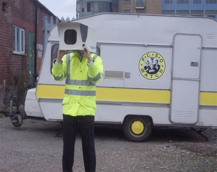
Image from the workshop Control Sonoro

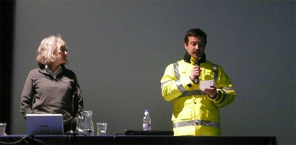
There were workshops, concerts, presentations, screenings and talks. One of the highlights of the week for me was Lisa Parks‘ talk. Her lecture was part of Critical Powers which invited thinkers and creators to share their views on the possible functions of utopia in an era of advanced Capitalism, the effects of technology changes on cultural process, or on the power of a public sphere.

Lisa Parks, Ph.D., is Associate Professor of Film and Media Studies at UC Santa Barbara. She is the author of Cultures in Orbit: Satellites and the Televisual and co-editor of Planet TV: A Global Television Reader. Her research explores uses of satellite, computer and television technologies in a transnational context.

ZEMOS98 put a tiny extract of the presentation online:

And i’ll add my notes:

Introduction

The lecture was articulated around two themes (Spying and Dreaming) and was a small compendium of the many topics she has been working on over the past few years, most of the material she presented is based on case studies but for lack of time she merely glossed over them.

Her first slide showed us a list of satellites that Spain has ownership on. Most are used for remote sensing. The first one (intersat) was launched in 1974, the latest DEIMOS in 2008 which will be used for disaster management. Parks stressed the importance of developing more literacy about satellites. We can name tv channels and websites by wouldn’t be able to name satellites. Throughout history, hundreds of satellites have been launched into space.

Another of her key interests is the visualization of satellites. We can have an everyday tactile contact with other technologies like mobile phones or television sets but our experience of satellites is very different. Right from the start as satellites are a highly specialized technology. They have to be constructed in clean room, protected from the rest of the world and they are launched in locations which are often closed off for security purpose. Once they are sent into orbit, most of us will never think about them again.

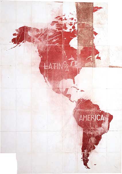
Parks then talked about the footprint of satellites. No matter how clearly defined the boundaries of nations can be, their space will always be crisscrossed by footprints from different satellites launched by various countries. Spain uses satellite technology to beam its signal to Latin America for example. That’s what she calls “Nation Beaming”.

Spying

1. The Corona Project

The Corona Project was a top secret program run by the CIA with the help of the US Air Force. One of them was hidden in Discoverer Spacecraft which contained biological experiments (to check how plants would withstand being launched into orbit). The project was top secret and involved a huge capital investment that the public financed without ever knowing about it.

0aacoronachut.jpg
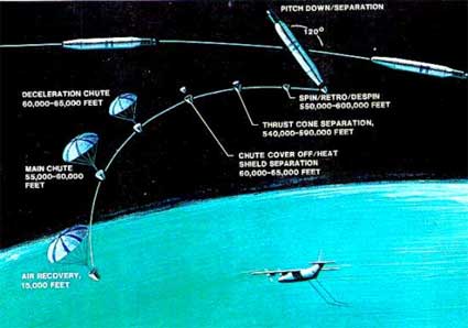
Corona film recovery diagram

Of the 144 Corona satellites launched, 102 returned usable images.
The Corona satellites secretly monitored and gathered a huge amount of satellite data about USSR, Eastern Europe and Asia from 1960 until 1972.
The program was declassified by President Clinton in 1995 and he made the images collected available to the public.

0aacatchcorona.jpg
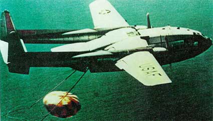
Catch of a Corona capsule off of Hawaii (image)

The recovery of the images taken by Corona was quite remarkable. A mechanism would drop the film canister and drop it in the air. The canister would then be recovered in mid-air by a C-119 aircraft. If the recovery mission failed, the canister would deploy a parachute and be recovered on earth or on the ocean.

The Corona program was initiated during the Cold War to check if “the other” was developing new weapons. The satellites were thus used to develop an image intelligence which would help the government decide on their own internal and external policy.

0aacoronaruins.jpg
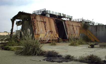
Corona launch preparation shed in ruins (image)

The Corona facility are now in decay.

2. Satellite imaging and global conflicts

It’s also important to discuss the relationship between orbit and earth in the age of image intelligence and see how remote sensing get integrated into news culture, how and when classified images suddenly make their way into our global media culture. More precisely the questions her research is focusing on are:

How have satellite images been used to represent global conflicts in the public sphere?
Where does the authority to use and interpret satellite images come from?
What kinds of phenomena and events do satellite images represent?
Have satellite images increased public awareness and knowledge about global conflict?
How have practice and meaning of “intervention” changed in the digital age?

First case study: Rwanda

0aarwandnna.jpg
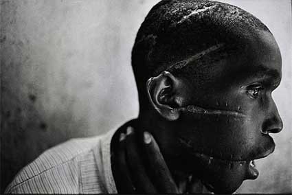
James Nachtwey, Survivor of Hutu death camp, Rwanda, 1994

Refugees International used aerial and sat images in 1996 to try to find and assist 1 million displaced persons. The combination of sat/aerial images was used as a medium that could uniquely visualize a “nationless social body”. The organization understood how these images could capture better than any other medium the displacement of a moving mass of people who have nowhere to go.

Many satellite images have to be inscribed with caption, without them the images lose their significance, they look like abstract paintings. We need to be directed to read these images.

Pressured US to release sat images to draw world attention to a conflict that was being ignored by the international community.

Second case study: Bosnia, July 1995

0aamassgrvvv.jpg
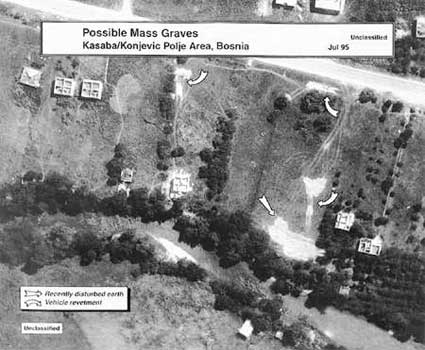
Satellite photo of Nova Kasaba mass graves.

US was boasting to have real time visibility over the war theatre – Information Dominance
Srebrenica is US-protected, highly monitored and as such regarded as a “Safe Haven”.
US State Department released sat images of alleged mass graves in Srebrenica 6 weeks after the massacre occurred.
Sat evidence of atrocities released after the fact, rather than during the act. The US State department claimed that the problem was that volume of sat data was to plentiful.

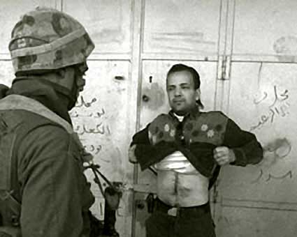
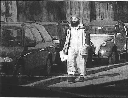
Case study 3. Colin Powell and Irak, 2003

0aaslidetajjii.jpg
Slide 12 of Powell’s address

Powell presented sat images in his address to the UN Security Council to make the case for a US-led war against Irak, alleging they contained “undeniable proof” of Iraqi development of weapons of mass destruction.

From Lisa Parks vantage point the case raises a real problem as Powell not only plagiarized a PhD thesis but, more crucially, the whole story undermined the credibility of any future use of sat images by US official in a global forum.

Satellite images are digital images and have thus no physical reference, they are generated by a series of 0 and 1. Yet they are useful. One shouldn’t embrace them as state truth but as a field of investigation. The 3 case studies highlight how much has changed in the US after the Corona programme.

Institutional Changes

The privatization sector is led by European companies:
1983 SPOT (Satellite Pour l’Observation de la Terre) begins selling sat images – 10 m resolution, meaning that an object 10 m long can be visible from space.
1987 Soviet company Soyuzkarta joins the game. They charge $500 to $800 for images of 5 m resolution, a price affordable for States or corporations.
1994 Clinton administration privatizes remote sensing in the US. The technology can no longer be used solely by CIA and the scientific but can be tuned into a profi-making industry.
The privatization of remote sensing occurs throughout the ’80s and ’90s.
In the 1990s Earthwatch and Space Imaging emerge and sell images of 1 m resolution.

Today the website of Satellite Imaging Corporation claims that they are the largest because they are the one who possess most satellite assets. They own a fleet of satellite, one of them moves makes a complete turn of the Earth in 90 minutes.

The commercialization of sat images has led to some odd uses and requests.

In 2001, Dan Bollinger, a fan of the tv program Survivor: Africa, sent a request to Space Imaging to acquire the image data over the Kenya location and share them with other fans of the show. The CBS facilities were discovered but the tv channel didn’t want to see their production site exposed.

The images nevertheless traveled all over the world showing that satellite images are no longer a matter of security issue but are part of a broader visual culture.

0akfcclogo.jpg

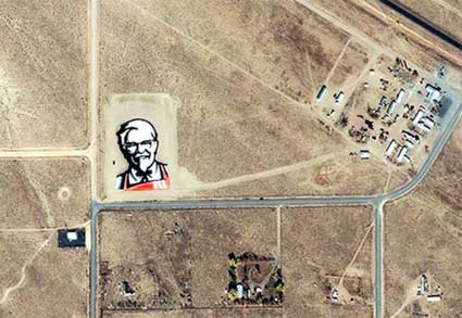
Another case which illustrates the previous statement come from a campaign by KFC. The fried chicken company needed to re-design the brand and came up with the “Face from Space” in the Nevada desert, also known as the “UFO Capital of the World.” The fast food company purchased an Ikonos image of the site and distributed it through global media circuits.

While satellites have historically passed over the earth to observe “naturally unfolding” phenomena, now events are staged precisely so they can be viewed from an orbital perspective. Remote sensing satellites are now being used to pitch products and address global consumers just as other media such as commercial television or the world wide web. More in this article by Lisa Parks: Obscure Objects of Media Studies: Echo, Hotbird and Ikonos.

Google Earth

Since 2005, Google Earth presents us with a “mosaic’ed” version of the world using satellite images coming from various sources. But while the logo of Google is always clearly visible on the images, no matter how blurry they are themselves, we are kept in the dark regarding the satellites used to compose these images. Google Earth is a great opportunity to educate the public about satellite but instead they do GE tends to almost erase the existence of the satellites.

Digital Globe provides date information for satellite images that are part of Google Earth using color-coded squares and “I” icons. By clicking on “preview,” you enter a meta-browser featuring the single satellite image captioned with information about how to purchase it or others from Digital Globe. Digital Globe is thus providing date information as part of a marketing strategy. GE becomes a billboard.

0aagoogldarfur.jpg
(image)

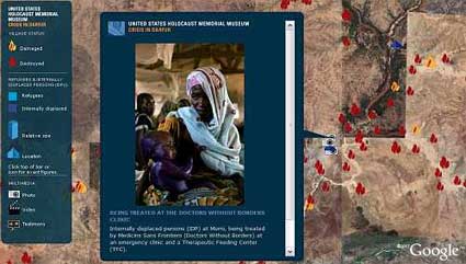
Google Earth teamed up with the United States Holocaust Memorial Museum to create the Crisis in Darfur mapping initiative which collects and diffuses visual evidence of the destruction in Darfur.

On the surface it looks like an admirable project but in several ways it missed the opportunity to represent the conflict in all its complexities. It uses tropes to represent African tragedy (images of suffering children carried by their mother). There is no visible effort of providing a political and economical education about the tragedy.

With the slide i pasted below, Lisa Park claims to demonstrate that earlier media news provided more opportunities for education:

0aaeclipsingsatima.jpg

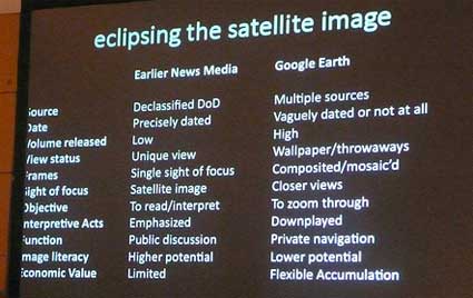
Problems of GE Crisis in Darfur layer:
– obscure satellite imagery,
– represents the “past perfect”, because it show what we monitored from space but didn’t do anything about at the time,
– involves the branding of global conflicts (no matter how blurry the image, the Google brand is always conspicuous),
– exemplifies neoliberalism (David Harvey) and disaster capitalism (Naomi Klein),
– from CNN effect to Google Earth effect? In order to get world attention will an event have to appear on Google Earth?

What does it mean for a US corporation to reproduce foreign territory as they want and without asking permission (some nations actually complained that GE causes a serious security concern.)

In a nutshell:

The public remains relatively uninformed about satellites, their uses and their impact on everyday life even though citizens taxes subsidize satellite developments.

The second part of Lisa Parks was about The Dreamers, the artists who use and comment on satellite technology. I found this part a bit weaker (less documented and with errors in the orthography of the artists’ names, happens to everyone of course but look quite bad on slides.) But here are a few notes:

“The Dreamers” encourage us to see and reflect about sat technologies and their potentials. they dare to experiment with satellites (traditionally seen as a heavy and highly specialized technology) and how they are used. Encourage us to think about who owns and control, satellites, orbital space and the spectrum. Develop uses that are not just about state security or corporate profits but about citizens’ needs.

Artists acknowledged in her presentation about satellite art and activism:
Kit Galloway and Sherri Rabinowitz,
Douglas Davis,
Brian Springer,
Marko Peljhan,
Trevor Paglen,
and a special and enthusiastic mention of Aram Bartholl.

Last recommendations from Parks:

Investigate satellites, learn their names, who owns them, what they do, how they have been used. There is a need for more satellite literacy.

Contest the militaristic and corporate appropriation of satellites with more art, activism, dreaming and experimentation.

Imagine how the use of satellite in the public interest might be defined.

Image on the homepage showing Laika, a dog launched in orbit together with the satellite Sputnik II in 1957.