ZEMOS98: Lisa Parks on Satellite Secrets: Between Spying and Dreaming
Posted in: Uncategorized
Back from the 10th edition of ZEMOS98, a festival of audiovisual culture titled this year Regreso al futuro, Back to the Future. I wish all the events i attend were as intelligently curated, carefully organized and stimulating as this one. The audience was great too. And extremely polite: they sat all the way through the talk i gave there in a spanish bastardized with franco-italian words and grammar.

Image from the workshop Control Sonoro
There were workshops, concerts, presentations, screenings and talks. One of the highlights of the week for me was Lisa Parks‘ talk. Her lecture was part of Critical Powers which invited thinkers and creators to share their views on the possible functions of utopia in an era of advanced Capitalism, the effects of technology changes on cultural process, or on the power of a public sphere.
Lisa Parks, Ph.D., is Associate Professor of Film and Media Studies at UC Santa Barbara. She is the author of Cultures in Orbit: Satellites and the Televisual and co-editor of Planet TV: A Global Television Reader. Her research explores uses of satellite, computer and television technologies in a transnational context.
ZEMOS98 put a tiny extract of the presentation online:
And i’ll add my notes:
Introduction
The lecture was articulated around two themes (Spying and Dreaming) and was a small compendium of the many topics she has been working on over the past few years, most of the material she presented is based on case studies but for lack of time she merely glossed over them.
Her first slide showed us a list of satellites that Spain has ownership on. Most are used for remote sensing. The first one (intersat) was launched in 1974, the latest DEIMOS in 2008 which will be used for disaster management. Parks stressed the importance of developing more literacy about satellites. We can name tv channels and websites by wouldn’t be able to name satellites. Throughout history, hundreds of satellites have been launched into space.
Another of her key interests is the visualization of satellites. We can have an everyday tactile contact with other technologies like mobile phones or television sets but our experience of satellites is very different. Right from the start as satellites are a highly specialized technology. They have to be constructed in clean room, protected from the rest of the world and they are launched in locations which are often closed off for security purpose. Once they are sent into orbit, most of us will never think about them again.
Parks then talked about the footprint of satellites. No matter how clearly defined the boundaries of nations can be, their space will always be crisscrossed by footprints from different satellites launched by various countries. Spain uses satellite technology to beam its signal to Latin America for example. That’s what she calls “Nation Beaming”.
Spying
1. The Corona Project
The Corona Project was a top secret program run by the CIA with the help of the US Air Force. One of them was hidden in Discoverer Spacecraft which contained biological experiments (to check how plants would withstand being launched into orbit). The project was top secret and involved a huge capital investment that the public financed without ever knowing about it.
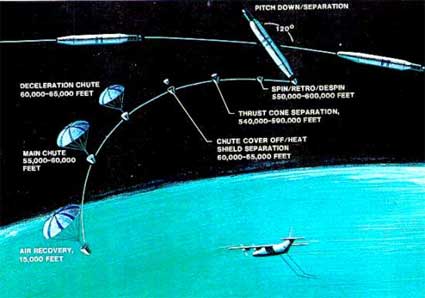
Corona film recovery diagram
Of the 144 Corona satellites launched, 102 returned usable images.
The Corona satellites secretly monitored and gathered a huge amount of satellite data about USSR, Eastern Europe and Asia from 1960 until 1972.
The program was declassified by President Clinton in 1995 and he made the images collected available to the public.
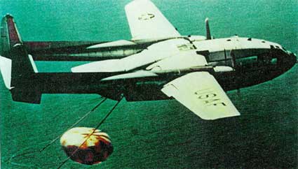
Catch of a Corona capsule off of Hawaii (image)
The recovery of the images taken by Corona was quite remarkable. A mechanism would drop the film canister and drop it in the air. The canister would then be recovered in mid-air by a C-119 aircraft. If the recovery mission failed, the canister would deploy a parachute and be recovered on earth or on the ocean.
The Corona program was initiated during the Cold War to check if “the other” was developing new weapons. The satellites were thus used to develop an image intelligence which would help the government decide on their own internal and external policy.
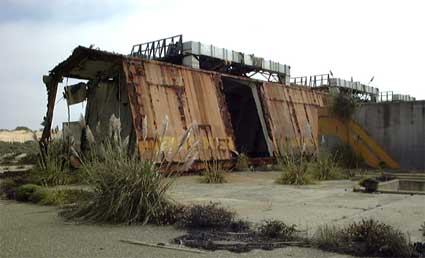
Corona launch preparation shed in ruins (image)
The Corona facility are now in decay.
2. Satellite imaging and global conflicts
It’s also important to discuss the relationship between orbit and earth in the age of image intelligence and see how remote sensing get integrated into news culture, how and when classified images suddenly make their way into our global media culture. More precisely the questions her research is focusing on are:
Where does the authority to use and interpret satellite images come from?
What kinds of phenomena and events do satellite images represent?
Have satellite images increased public awareness and knowledge about global conflict?
How have practice and meaning of “intervention” changed in the digital age?
First case study: Rwanda

James Nachtwey, Survivor of Hutu death camp, Rwanda, 1994
Refugees International used aerial and sat images in 1996 to try to find and assist 1 million displaced persons. The combination of sat/aerial images was used as a medium that could uniquely visualize a “nationless social body”. The organization understood how these images could capture better than any other medium the displacement of a moving mass of people who have nowhere to go.
Many satellite images have to be inscribed with caption, without them the images lose their significance, they look like abstract paintings. We need to be directed to read these images.
Pressured US to release sat images to draw world attention to a conflict that was being ignored by the international community.
Second case study: Bosnia, July 1995
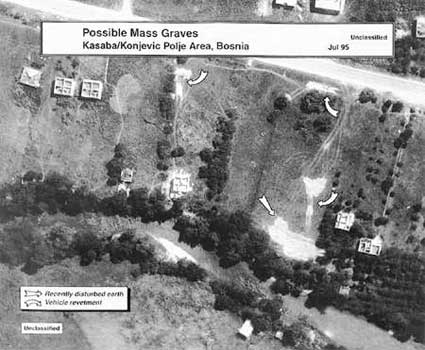
Satellite photo of Nova Kasaba mass graves.
US was boasting to have real time visibility over the war theatre – Information Dominance
Srebrenica is US-protected, highly monitored and as such regarded as a “Safe Haven”.
US State Department released sat images of alleged mass graves in Srebrenica 6 weeks after the massacre occurred.
Sat evidence of atrocities released after the fact, rather than during the act. The US State department claimed that the problem was that volume of sat data was to plentiful.
Case study 3. Colin Powell and Irak, 2003
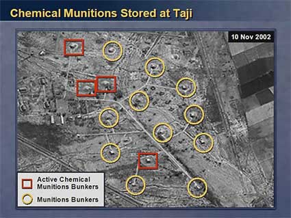
Slide 12 of Powell’s address
Powell presented sat images in his address to the UN Security Council to make the case for a US-led war against Irak, alleging they contained “undeniable proof” of Iraqi development of weapons of mass destruction.
From Lisa Parks vantage point the case raises a real problem as Powell not only plagiarized a PhD thesis but, more crucially, the whole story undermined the credibility of any future use of sat images by US official in a global forum.
Satellite images are digital images and have thus no physical reference, they are generated by a series of 0 and 1. Yet they are useful. One shouldn’t embrace them as state truth but as a field of investigation. The 3 case studies highlight how much has changed in the US after the Corona programme.
Institutional Changes
The privatization sector is led by European companies:
1983 SPOT (Satellite Pour l’Observation de la Terre) begins selling sat images – 10 m resolution, meaning that an object 10 m long can be visible from space.
1987 Soviet company Soyuzkarta joins the game. They charge $500 to $800 for images of 5 m resolution, a price affordable for States or corporations.
1994 Clinton administration privatizes remote sensing in the US. The technology can no longer be used solely by CIA and the scientific but can be tuned into a profi-making industry.
The privatization of remote sensing occurs throughout the ’80s and ’90s.
In the 1990s Earthwatch and Space Imaging emerge and sell images of 1 m resolution.
Today the website of Satellite Imaging Corporation claims that they are the largest because they are the one who possess most satellite assets. They own a fleet of satellite, one of them moves makes a complete turn of the Earth in 90 minutes.
The commercialization of sat images has led to some odd uses and requests.
In 2001, Dan Bollinger, a fan of the tv program Survivor: Africa, sent a request to Space Imaging to acquire the image data over the Kenya location and share them with other fans of the show. The CBS facilities were discovered but the tv channel didn’t want to see their production site exposed.
The images nevertheless traveled all over the world showing that satellite images are no longer a matter of security issue but are part of a broader visual culture.
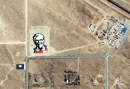
Another case which illustrates the previous statement come from a campaign by KFC. The fried chicken company needed to re-design the brand and came up with the “Face from Space” in the Nevada desert, also known as the “UFO Capital of the World.” The fast food company purchased an Ikonos image of the site and distributed it through global media circuits.
While satellites have historically passed over the earth to observe “naturally unfolding” phenomena, now events are staged precisely so they can be viewed from an orbital perspective. Remote sensing satellites are now being used to pitch products and address global consumers just as other media such as commercial television or the world wide web. More in this article by Lisa Parks: Obscure Objects of Media Studies: Echo, Hotbird and Ikonos.
Google Earth
Since 2005, Google Earth presents us with a “mosaic’ed” version of the world using satellite images coming from various sources. But while the logo of Google is always clearly visible on the images, no matter how blurry they are themselves, we are kept in the dark regarding the satellites used to compose these images. Google Earth is a great opportunity to educate the public about satellite but instead they do GE tends to almost erase the existence of the satellites.
Digital Globe provides date information for satellite images that are part of Google Earth using color-coded squares and “I” icons. By clicking on “preview,” you enter a meta-browser featuring the single satellite image captioned with information about how to purchase it or others from Digital Globe. Digital Globe is thus providing date information as part of a marketing strategy. GE becomes a billboard.
(image)
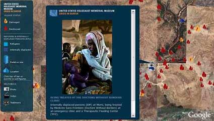
Google Earth teamed up with the United States Holocaust Memorial Museum to create the Crisis in Darfur mapping initiative which collects and diffuses visual evidence of the destruction in Darfur.
On the surface it looks like an admirable project but in several ways it missed the opportunity to represent the conflict in all its complexities. It uses tropes to represent African tragedy (images of suffering children carried by their mother). There is no visible effort of providing a political and economical education about the tragedy.
With the slide i pasted below, Lisa Park claims to demonstrate that earlier media news provided more opportunities for education:
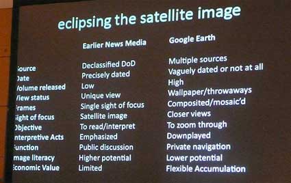
Problems of GE Crisis in Darfur layer:
– obscure satellite imagery,
– represents the “past perfect”, because it show what we monitored from space but didn’t do anything about at the time,
– involves the branding of global conflicts (no matter how blurry the image, the Google brand is always conspicuous),
– exemplifies neoliberalism (David Harvey) and disaster capitalism (Naomi Klein),
– from CNN effect to Google Earth effect? In order to get world attention will an event have to appear on Google Earth?
What does it mean for a US corporation to reproduce foreign territory as they want and without asking permission (some nations actually complained that GE causes a serious security concern.)
In a nutshell:
The public remains relatively uninformed about satellites, their uses and their impact on everyday life even though citizens taxes subsidize satellite developments.
The second part of Lisa Parks was about The Dreamers, the artists who use and comment on satellite technology. I found this part a bit weaker (less documented and with errors in the orthography of the artists’ names, happens to everyone of course but look quite bad on slides.) But here are a few notes:
“The Dreamers” encourage us to see and reflect about sat technologies and their potentials. they dare to experiment with satellites (traditionally seen as a heavy and highly specialized technology) and how they are used. Encourage us to think about who owns and control, satellites, orbital space and the spectrum. Develop uses that are not just about state security or corporate profits but about citizens’ needs.
Artists acknowledged in her presentation about satellite art and activism:
– Kit Galloway and Sherri Rabinowitz,
– Douglas Davis,
– Brian Springer,
– Marko Peljhan,
– Trevor Paglen,
and a special and enthusiastic mention of Aram Bartholl.
Last recommendations from Parks:
Contest the militaristic and corporate appropriation of satellites with more art, activism, dreaming and experimentation.
Imagine how the use of satellite in the public interest might be defined.
Image on the homepage showing Laika, a dog launched in orbit together with the satellite Sputnik II in 1957.

Post a Comment